g0201_0300.s0218_the_skyline_problem.readme.md Maven / Gradle / Ivy
Go to download
Show more of this group Show more artifacts with this name
Show all versions of leetcode-in-java21 Show documentation
Show all versions of leetcode-in-java21 Show documentation
Java-based LeetCode algorithm problem solutions, regularly updated
218\. The Skyline Problem
Hard
A city's **skyline** is the outer contour of the silhouette formed by all the buildings in that city when viewed from a distance. Given the locations and heights of all the buildings, return _the **skyline** formed by these buildings collectively_.
The geometric information of each building is given in the array `buildings` where buildings[i] = [lefti, righti, heighti]:
* lefti is the x coordinate of the left edge of the ith building.
* righti is the x coordinate of the right edge of the ith building.
* heighti is the height of the ith building.
You may assume all buildings are perfect rectangles grounded on an absolutely flat surface at height `0`.
The **skyline** should be represented as a list of "key points" **sorted by their x-coordinate** in the form [[x1,y1],[x2,y2],...]. Each key point is the left endpoint of some horizontal segment in the skyline except the last point in the list, which always has a y-coordinate `0` and is used to mark the skyline's termination where the rightmost building ends. Any ground between the leftmost and rightmost buildings should be part of the skyline's contour.
**Note:** There must be no consecutive horizontal lines of equal height in the output skyline. For instance, `[...,[2 3],[4 5],[7 5],[11 5],[12 7],...]` is not acceptable; the three lines of height 5 should be merged into one in the final output as such: `[...,[2 3],[4 5],[12 7],...]`
**Example 1:**

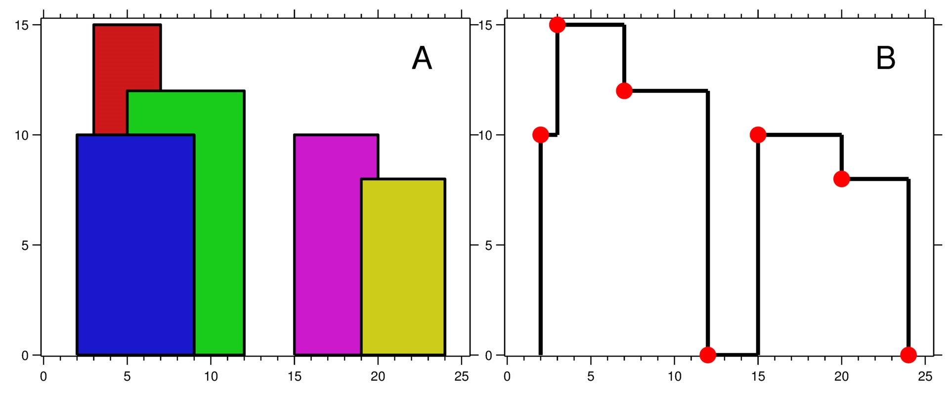
**Input:** buildings = [[2,9,10],[3,7,15],[5,12,12],[15,20,10],[19,24,8]]
**Output:** [[2,10],[3,15],[7,12],[12,0],[15,10],[20,8],[24,0]]
**Explanation:**
Figure A shows the buildings of the input.
Figure B shows the skyline formed by those buildings.
The red points in figure B represent the key points in the output list.
**Example 2:**
**Input:** buildings = [[0,2,3],[2,5,3]]
**Output:** [[0,3],[5,0]]
**Constraints:**
* 1 <= buildings.length <= 104
* 0 <= lefti < righti <= 231 - 1
* 1 <= heighti <= 231 - 1
* `buildings` is sorted by lefti in non-decreasing order.
